guidebee

January 7, 2011

Map Class Hierarchy

Filed under: GPS Navigation,Mobile Map API — guidebee @ 4:23 pm
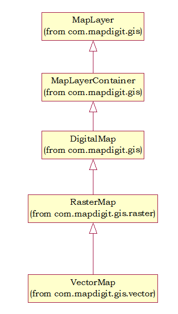
MapLayer define common map operation, like setCenter, Zoom in, Zoom out, Pan Direction and coordinates conversion (from Map to screen and vice versa) and it’s a common base class for all digital map.


MapLayerContainer is container classes; manage a collection of Map layers allow them setCenter, Zoom In, Zoom out and Pan Direction together.


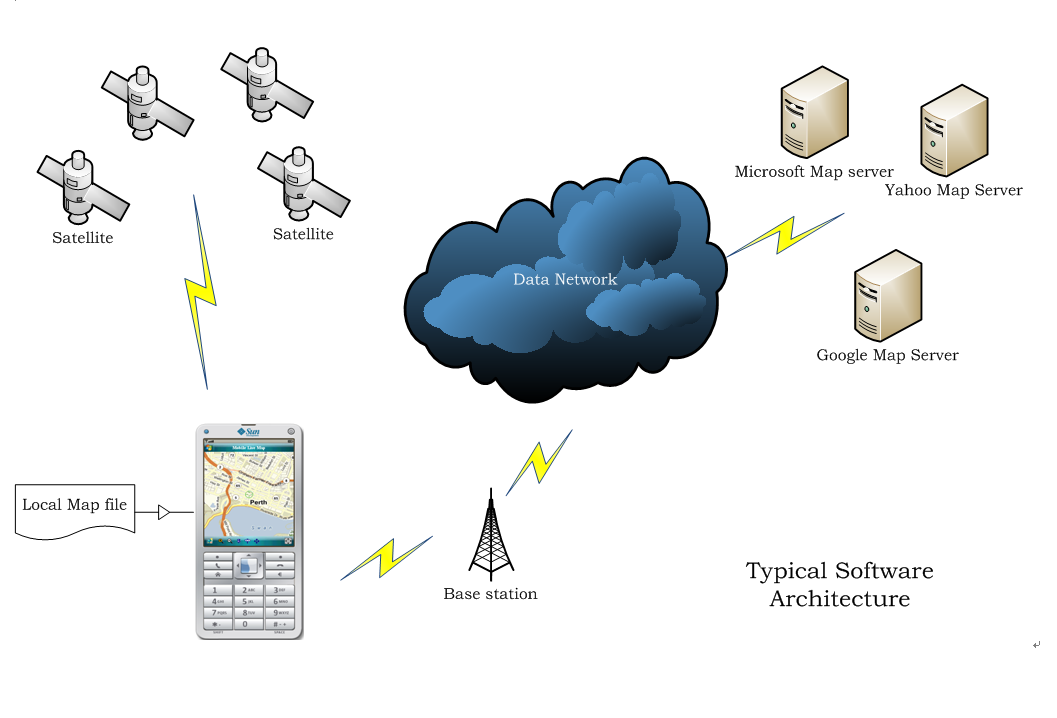
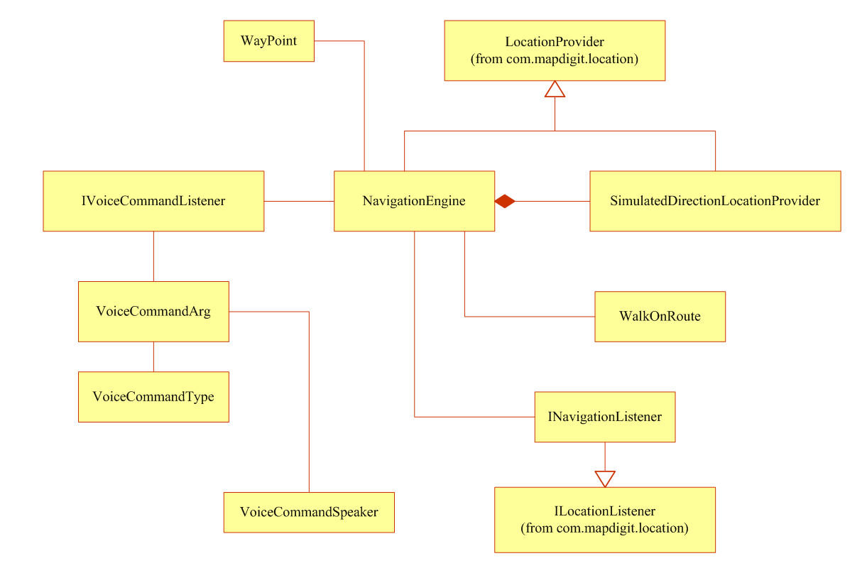
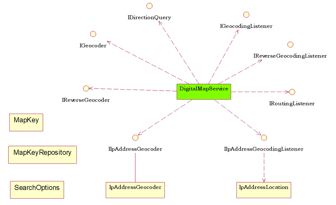
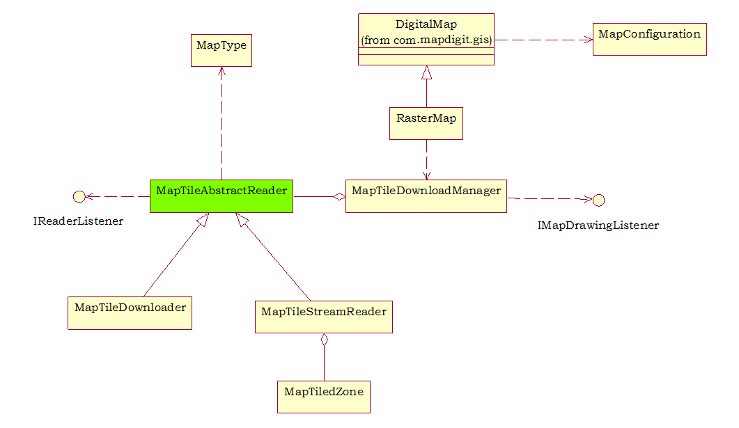
DigitalMap introduces Map Services like Geocoding, Reverse Geocoding and Routing service. It supports incorporate different Map Services implementation.


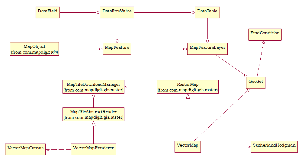
RasterMap deals with online, stored map images tiles, it support multi-threads and also provide listener to monitor the progress of downloading or reading map image tiles.


VectorMap is a subclass of RasterMap, so it supports all functions provided by RasterMap, instead of downloading image tiles from map server or reading map image tiles from local files, Vector renders map image tile from MapInfo compatible vector map file also supports Geoset which managers multiple map feature layers.

Typical Software architecture

Filed under: Mobile Map API — guidebee @ 4:20 pm

Guidebee Map API –Package Drawing.Geometry

Filed under: Mobile Map API,Uncategorized — guidebee @ 4:18 pm

Package geometry provides the Java 2D classes for defining and performing operations on objects related to two-dimensional geometry.

PathIterator
The PathIterator interface provides the mechanism for objects that implement the Shape interface to return the geometry of their boundary by allowing a caller to retrieve the path of that boundary a segment at a time.
IShape
The Shape interface provides definitions for objects that represent some form of geometric shape.
AffineTransform
The AffineTransform class represents a 2D affine transform that performs a linear mapping from 2D coordinates to other 2D coordinates that preserves the “straightness” and “parallelness” of lines.
Arc
Arc store a 2D arc defined by a framing rectangle, start angle, angular extent (length of the arc), and a closure type (OPEN, CHORD, or PIE).
Area
An Area object stores and manipulates a resolution-independent description of an enclosed area of 2-dimensional space.
CubicCurve
The CubicCurve class defines a cubic parametric curve segment in (x, y) coordinate space.
Dimension
The Dimension class encapsulates the width and height of a component (in integer precision) in a single object.
Ellipse
The Ellipse class describes an ellipse that is defined by a framing rectangle.
FlatteningPathIterator
The FlatteningPathIterator class returns a flattened view of another PathIterator object.
Path
The Path class represents a geometric path constructed from straight lines, and quadratic and cubic (Bezier) curves.
Line
This Line represents a line segment in (x, y) coordinate space.
Point
A point representing a location in (x, y) coordinates space, specified in integer precision.
Polygon
The Polygon class encapsulates a description of a closed, two-dimensional region within a coordinate space.
Polyline
The Polyline class encapsulates a description of a collection of line segments within a coordinate space.
QuadCurve
The QuadCurve class defines a quadratic parametric curve segment in (x, y) coordinate space.
Rectangle
A Rectangle specifies an area in a coordinate space that is enclosed by the Rectangle object’s upper-left point (x, y) in the coordinate space, its width, and its height.
RectangularShape
RectangularShape is the base class for a number of Shape objects whose geometry is defined by a rectangular frame.
RoundRectangle
The RoundRectangle class defines a rectangle with rounded corners defined by a location (x, y), a dimension (w x h), and the width and height of an arc with which to round the corners.

Guidebee Map API –Package Drawing

Filed under: Mobile Map API,Uncategorized — guidebee @ 4:17 pm

The Drawing package provides access to basic 2D graphics functionality.


Brush
Classes derived from this abstract base class define objects used to fill the interiors of graphical shapes such as rectangles, ellipses, pies, polygons, and paths.
Color
The Color class is used to encapsulate colors in the default serge color space Every color has an implicit alpha value of 1.0 or an explicit one provided in the constructor.
Graphics2D
This Graphics2D class provides more sophisticated control over geometry, coordinate transformations, color management, and text layout.
LinearGradientBrush
The LinearGradientBrush class provides a way to fill a Shape with a linear color gradient pattern.
Pen
The Pen class defines a basic set of rendering attributes for the outlines of graphics primitives, which are rendered with a Graphics2D object that has its Stroke attribute set to this Pen.
RadialGradientBrush
The RadialGradientBrush class provides a way to fill a shape with a circular radial color gradient pattern.
SolidBrush
Defines a brush of a single color.
TextureBrush
The TextureBrush class provides a way to fill a Shape with a texture that is specified as an Image.

Guidebee Map API –Package Gis.Navigation

Filed under: Mobile Map API,Uncategorized — guidebee @ 4:13 pm
The location packages defines API which provide turn by turn navigation instruction, the core class is NavigationEngine, it internally includes three working thread
  • Location monitor thread used to monitor current location against current navigation route if there’s one and adjust raw location to the nearest position on the route.
  • Voice command generator generate thread create upcoming voice command based on current step and location and put them to the voice command queue.
  • Voice command processor pick up the voice command from the queue and notify the voice command listenerHere’s state transition diagram of NavigationEngine:

Classes defined in this package
WayPoint
Define a navigation way point; it defines the name and Lat/Lng pair.
NavigationEngine
Navigation Engine, it internal has a navigation simulation thread ,it support turn by turn navigation , has on road and off road navigation mode, rerouting support etc.
SimulatedDirectionLocationProvider
Simulation location provider, it uses a MapDirection object as the simulation source.
VoiceCommandArg
Voice command argument class, which defines command type, command argument (which usually is the current road name)
VoiceCommandSpeaker
Default implementation for audio command player.
VoiceCommandType
Define all navigation command type, such as distance to a turn, turn left ,turn right etc.
WalkOnRoute
Current position on the route (nearest).
INavigationListener
Navigation listener, which monitor the status of the navigation engine, location update, rerouting status etc.
IVoiceCommandListener
Voice command listener.

Guidebee Map API –Package Gis.Location

Filed under: Mobile Map API,Uncategorized — guidebee @ 4:10 pm

The location packages defines API provide a common interface for GPS devices. The implementations provide a wrapper classes for JSR179 API, and also support NMEA compatible devices.

Coordinates
The Coordinates class represents coordinates as latitude-longitude-altitude values.
Location
The Location class represents the standard set of basic location information.
LocationProvider
This is the starting point for applications using location information in this API and represents a source of the location information.
Orientation
The Orientation class represents the physical orientation of the terminal.
QualifiedCoordnates
The QualifiedCoordinates class represents coordinates as latitude-longitude-altitude values that are associated with an accuracy value
JSR179LocationProvider
Wrapper class for JSR179 API locationProvider
NMEACompatibleLocationProvider
Base class for NMEA compatible devices.

Guidebee Map API –Package Gis.Vector

Filed under: Mobile Map API,Uncategorized — guidebee @ 4:00 pm

Vector package define objects for vector map

SutherlandHodgman
Implements Sutherland-Hodgman clip algorithm.
VectorMap
VectorMap is the basic building blocks for Guidebee vector map. Each map is consists of multiple map Layers.
GeoSet
The Geoset object is built off the Map object and allows you to define a geoset. A Geoset is a collection of map layers and their settings.
MapFeatureLayer
MapLayer defines a map layer.Computer maps are organized into layers.
MapFeature
MapFeature defines a map feature in a map layer.
DataTable
Defines one tabular database table
DataField
Defines a field of a database table.
DataRowValue
Defines a row of a database table.
FindCondition
Defines a find condition when search for records.
FindConditions
Defines a find condition collection when search for records.

Guidebee Map API –Package Gis.Service

Filed under: Mobile Map API,Uncategorized — guidebee @ 3:54 pm

The service defines interface for Digital map services (Geocoding, reverse Geocoding and routing etc).


DigitalMapServer
Default implementation for Map Service (routing, Geocoding ,reverse Geocoding)
IDirectionQuery
Interface to query routing information..
IGeocoder
Interface to find address.
IReverseGeocoder
Interface to find address based on its latitude and longitude.
IIpaddressGeocoder
Interface to find address based on its ip address (may not included in this release).
IGeocodingListener
Call back when Geocoding is done.
IReverseGeocodingListener
Callback when reverse Geocoding is done.
IRoutingListener
Callback when routing is done.
IIpaddressGeocodingListener
Callback when IP Geocoding is done.
IpAddressGeocoder
Default implementation of IP Geocoding service.
MapKey
Define map key used by map services
MapKeyRepository
Manage map keys
SearchOption
Define options for using map services.

Guidebee Map API –Package Gis.Raster

Filed under: Mobile Map API,Uncategorized — guidebee @ 3:52 pm

The raster package defines object used to raster maps (online or stored map)


Map Type
Define different map types (Google, Microsoft Live, Yahoo etc).
MapConfiguration
To fit for different device capability (memory size, screen size), the Map API can be configured to turn on/off cache, drawing routing polyline or not etc).these configuration will effect memory usage and performance of the Map API.
RasterMap
A core map class used to display map from server or from stored map file, provide panning, zooming etc.
MapTileAbstractReader
An abstract class defined how map tiles is obtained, connecting to map server, reading from local map files or rendering the vector map.
MapTileDownloader
MapTileDownloader download map image tiles from server (msn, yahoo, etc).
MapTileStreamReader
Read map image tiles from a input stream (mostly from local map file)
MapTileZone
A predefined stored map file. Developer can define their own stored map file format, if only it derives from MapTileAbstractReader.
IReaderListener
A listener used to monitor the progress of the reading
IMapDrawingListener
When a map reader finish downloading/reading/rendering a map tile, it trigs the listener to notify a map tile is available.

Guidebee Map API –Package Gis.Drawing

Filed under: Mobile Map API,Uncategorized — guidebee @ 3:50 pm

This package define a common interface for different Graphics System, such as MIDP Graphics or LWUIT  Graphics classes, with these interfaces ,Guidebee Digital Map can be used with different graphics systems.


AbstractGraphcsFactory
Factor class, used to create other graphics objects like font, graphics ,images etc.
IGraphics
Interface for Graphics object used to draw font, images etc, .
IFont
Font interface.
IImage
Image interface.

Next Page »

Blog at WordPress.com.

Design a site like this with WordPress.com
Get started